Saturday 17 October 2015

Malham Cove, the Gordale scar and my first proper scramble


The first time I went to malham was not long after I had done the first Llangollen walk.    


Planned route for the day

The plan was to walk past Janet's Foss, then scramble up the Goredale Scar, walk to the tarn, follow the river until it disappeared at Water Sinks. Then walk through the dry valley, connect up with the Pennine Way, walk the limestone paving over the top of Malham Cove, walk to the bottom of cove where the river reappears and complete the circuit back to the village.

 
Me, my mate, my sister (R Nicky) & Tess the dog

I decided to invest in some new boots rather than borrowing Aldi's finest boots of my dad. So I took myself off to Blacks and on my brother's instructions ask for a pair with a gore-tex membrane. When I saw the price I decided that a treated boot would suffice, so I picked up a pair of Berghaus AQ Explorers. Initially I was impressed, but then again I had no clue.


AQ "Waterproof" technology

New boots in hand, on a miserable grey spring morning we headed off to Malham. Our original plan was slightly modified when we realised that despite the four legged advantage Tess was not going to get up the Scar.  Secretly relieved, I suggested we walk up a hill at the mouth of the gorge instead, thinking it would be the easier option.

The hill AKA "bastard of a hill"

It was at this point I discovered that

A) my new boots were waterproof in name only

B) my new boots were useless on mud and offered zero traction.

As soon as we started across the field, walking through wet grass my feet were already starting to field damp. I guess AQ stands for aqueous, as my boots were definitely wet. Once we had crossed the field and a small wall we were at the bottom of the hill. The relatively steep hill which was initially the easier option started to look a bit more of a challenge. The moment I started walking up it felt near impossible. The very shallow cleats on the boots proved to be absolutely useless on the saturated ground.


Hands and knees provide the much needed traction the boots failed to offer 

After clawing my way up the hill. We walked along the top of gorge until we connected back up with our planned route. Most of the day was spend traipsing through mizzle and rain. 

A good portion of it was spent on my backside as I later discovered that my boots were useless on wet limestone (to be fair most boots are)


Doing the worm across the limestone paving

Hands and knees again supplying the traction
"Are we nearly there yet?"

Even though it was wet miserable day and my feet were sodden I still managed to enjoy myself. However, I think we all felt a little disappointed that we never made it up the gorge.

the face says it all.

So we promised to come back in fairer weather and scale the Gordale Scar.

In the interim I shelled out £190 on a pair of Meindl Bhutan MSF from Cotswolds. I wanted a pair of 3/4 season boots for the winter with good grip and a proper gore-tex lining after the previous adventure.

Genuinely waterproof boots

I could not be happier with the Meindls, I read a lot of reviews saving that they were very stiff and maybe not so comfortable for general walking. However, for me they were ideal! Initially they felt a bit weighty but when it came to kicking in steps up a snowy hill I found the weight reassuring.

Freshly kitted out on a cold but sunny February we headed back to Malham.

All ready and raring to go on frosty February morning.

We followed the exact same route of the original plan. Headed out the village through Janet's Foss.

On our way to Janet's Foss

Janet's Foss

Once we passed Janet's Foss started to approach the Gordale Scar. On our first outing my brother sold it as England's answer to the Grand Canyon. On a wet miserable day it didn't feel like it, but in the early morning sun on a beautiful day it was very impressive.

Entering the gorge

Looking back through the gorge

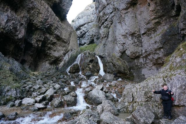
Once we entered the immense stone cathedral, the waterfall we were set to climb came into view. This time round rather than being apprehensive i was really excited. The previous night i must have watch every youtube video that showed even a glimpse of the climb up the waterfall.


the waterfall in all its glory 

"Are we going to climb that?!"

We approached the waterfall from the right hand side initially, we first had to traverse across the front of the waterfall over a few stepping stones. At this point we had to step up a human chain to walk my mate Murray's son and his friend across us. This is when the Meindl Bhutan boots and my gaiters came into there own. At one point i both my feet submerged up to my ankles for a few minutes and my feet stayed completely dry. Pity i couldn't say the same about Murray's son's friend's sweatpants after he took a quick dip on his way through the chain..

Actual route up the waterfall and my first ever proper scramble

Half way up the waterfall

Still passing children up the waterfall

Once we got over the first waterfall the gorge open up to reveal another dramatic waterfall cascading over the shattered floor of the canyon. We missed this completely last time as we had to skirt around the top of the gorge and couldn't get close enough to the edge to look down.

And what a view to miss

You can stick your Grand Canyon 

My brother looking absolutely chuffed

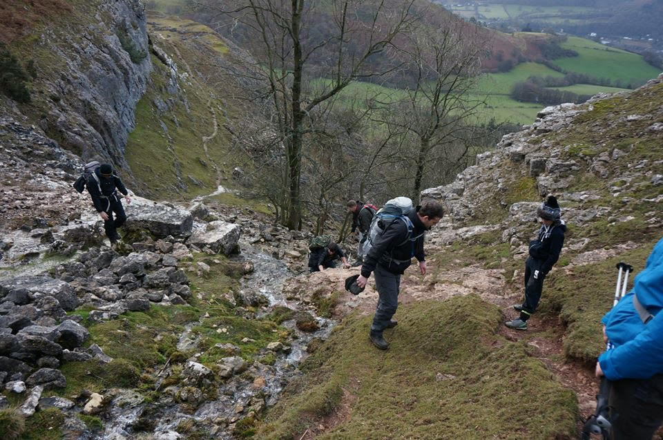
On the right hand side of the gorge were a rough a set of steps cut into the floor up a thigh burning hill and out of the valley. This was definitely a head-down-stamp-through-it moment.

Slogging up the hill

Gasping for air at the top of the hill

After a lot of huffing and puffing we reached the top of valley which opened out into a beautiful sunny day.

Looking up the valley


Looking back down into the gorge

after leaving the valley we headed towards Malham Tarn.


After briefly visiting malham tarn we followed the river until it disappears at "Water sinks." We then enter the dry valley of Watlowes heading towards the famous limestone paving on top of Malham Cove.


Dry river bed

Looking back along the dry valley of Watlowes

Once we passed through the dry valley we reached the world famous limestone paving. This time on a dry day the footing felt a lot more secure. However, where it was damp and in shadow, the polished rock was as slick as ice irrespective of my new boots.

The world famous limestone paving.

My sister and I at the top of the cove

It's a long way down

Limestone amphitheatre

After we passed the limestone paving there was a steep path down to the bottom of the cove. It was quite amazing following the path of the river, watching it disappear at "Water Sinks" and then have (what we thought was the river) spring back up a good mile or so at the bottom of a huge limestone amphitheater. It turns out according to this source, the origins of the spring are slightly more complicated 

"For many years, it was believed that this river was the same as Malham Beck, reemerging further down the valley at the base of Malham Cove (i.e. the most obvious course: simply tracing the route of the dry valley which leads from Water Sinks down to the cove itself - and which way the water would have almost certainly flowed before finding the route underground).
However, this is in fact not the case, as fluorescence dye tests have now proved that the river disappearing underground at Water Sinks does not actually reemerge until much further downstream, the point of debouchure being a place which is called Aire Head Springs south of Malham village. [Malham Beck, meanwhile, appears to originate at another location on Malham Moor, before also disappearing underground to resurface at the famous rising beneath Malham Cove !]"

The cove was dotted with climbers scaling its vertical walls, and on a sunny day I imagine there is no better place to be.


After visiting the spring we followed the river back out of the valley towards our start and finish point of Malham village for a well earned pint.


Breathtaking view looking back into the valley

It was a fantastic walk, and my first real taste of scrambling. Ever though it was only a short segment of the day, it had the most impact. There was real excitement and pleasure as I thought and worked my way up the waterfall. This was the ideal introduction to scrambling for me. The fact we managed to get two children up (no dogs unfortunately) demonstrated how easy it was, but at the time it still felt dangerous. I was hooked. Even though was a small step, it felt like a massive leap for me.

Wednesday 7 October 2015

Llangollen - Lost And Found

I remember Llangollen from my childhood holidays in North Wales. Like most kids from Liverpool, I spent huge chunk of my summers staying at my uncle's caravan visiting Colwyn Bay, Conway, Caernarfon, Loggerheads and Anglesey. Llangollen was a great hot summer's day destination to go swimming in the River Dee, or if you were mad enough - like my brother - jump from the bridge into the river itself. 

Fast forward 15 or so years and i was up at 06:00 on a miserable Sunday morning in February wearing a borrowed pair of Aldi's finest walking boots, a scruffy pair of combat pants and a 80 litre Bergen with no waist strap, packed to the hilt with sandwiches and bottles of water. My brother had been organising and going on walks with friends for a few years and kept asking me to come along. I'd always make excuses as I was in (I thought) no shape to be traipsing up and down hills, but this time round things were different. The previous June I had run a 10K and was fairly fit for my build, so I thought "why not give it a try," forgetting that I had run exactly 0K since that June!

We arrived at Llangollen for around 08:50 at the large car park off Mill Street and set off by 09:00 for the first high point of the day Castell Dinas Bran at 320 meters of fair steep incline (see route map).

Route map....can you guess where we got lost?

Within the first 20-30 minutes of the walk I was absolutely goosed. Even though there is an easy path it's fairly steep and I was absolutely pooped by the time we reached the top. 
 A nice "easy" path (panting author not pictured.)

After a lot of huffing and puffing we reached the top of the medieval fortification. Most of the way up I'd spent swearing under my breath, promising i would never agree to another "walk" and thinking of an exit route back to the cars. Then miraculously when we reached the top all the heartache was forgotten and in its place a real sense of achievement (even though this was a minor hill.)

 Our walking group, and one clearly elated author (second from right)

From the top of the hill fort we could the see rest of the route along the cliffs that frame the top of the valley and the length of Offa's Dyke. We had a short drop down the otherside of the hill fort and back into the valley to walk along the road until we hit the next challenge. 


The cliffs pictured in the distance 

The walk back down into the valley.

The next high point lay on top of the cliffs. Our route took us a short way down the valley, back on ourselves and up a small brook up to the top of the cliffs. Now all that previous heartache and internal moaning came rushing back. Standing at the bottom of those cliffs and looking up the small valley, I didn't fancy my chances.

The red line

According to my brother this wasn't a scramble, in hindsight I totally agree. In reality it was an easy ascent. At the time though - in my mind's eye - it looked near vertical.

Author not scrambling (camouflage backpack if you can see it)

Author still not scrambling (I'm the figure at the back.)

As I fought my way to the top my full vocabulary of swear words was loud and clear. Anyone within earshot could tell I was not a happy hill walker, let alone a mountaineer. After significant amounts of huffing and puffing, 'effing and jeffing I reached the top. The cotton band shirt (Red Fang \m/ {><} \m/) I decided to wear was now completely soaked with sweat. We stop for a breather at the top of the hill and then the cold hit me. It was only then I remembered my school DofE expedition and how we were told not to wear cotton as a base layer.

After a brief and blustery break we started making good progress along the tops of the cliffs towards world's end. From these tops we could make out perfectly the first high point we had reached then Dinas Bran, the Berwyn mountain range, the white peaks of Snowdon and the Glyders 

Castell Dinas Bran

Snowdon and The Glyders


The Berwyn range and the Vale of Llangollen

Eventually we reached World's End - and it felt like it - but we weren't even halfway. One of my brother's friends actually ask if we nearly at the car. My brother replied, slightly bewildered, "We have been walking in a straight line for the 2 hours or so what makes you think we are anywhere near the car?"

We then started to drop down the head of the valley at World's End through the dense woods down a steep path. The going was extremely muddy. At this point I lost the ends of both my walking poles which were then rendered completely useless. Every time I used them they would sink into the mud to the handles nearly.

Further into the woods we decided to have a fuel stop and pose for a team photo with my brother's new camera's timer function, After three or attempts we managed to take a picture. Continuing on, we dropped enough height that we at the bottom of the valley and on the road back to Llangollen.

Still with one pole end attached... but not for long

"Sod it, that will have to do" 

It's here where the actual route we took becomes a bit sketchy. At some point down the road we took a small detour and were quite happy until we were confronted with a field occupied by either a bull or a cow who was sporting a decent set of horns. Understandably my brother - the walk leader - was a bit concerned with the prospect of crossing said field, so he backtracked down to a farm to ask for directions (pictured wearing a "red rag to a bull" coloured jacket).

Illustrious walk leader in red asking for directions. (Note the farmer pointing in the direction had just come from.)

The news we had to backtrack back down the road was met with no great joy. We all slogged back down the road in near silence. At this point my legs and feet were not very happy either. This was the furthest they had ever carried me in one go. Everyone was feeling pretty exhausted.

We reached the right point which we needed to leave the road and join another footpath that took us to the correct farm we had to pass. This footpath start cutting up a hill until it reached its spine. At this point the route should have dropped from the spine of the ridge back down the flank of the hill and gently back to the road. Or it at least it should have. 

Instead "we" decide to elect for the more "interesting" route that continued along the spine of the hill, over a barbed wire fence and onto a pine tree plantation  with a 45◦ slope cover in about a foot deep of lose pine needles that hid ankle breaking rootes at every second step. At the bottom of the hill we were met by yet another barbed wire fence which we had to carefully get over without falling into oncoming traffic. I'm pretty sure we had our own little mass trespass. Thankfully we weren't met by the local gamekeeper.

...It felt steeper at the time 

The brown streak marks the route we took down the hill.

A short distance down the road we met another path that took us along the Eglwyseg river through a beautiful little valley. We then made our way around the back of Fron Fawr along past The Birches towards the remains of Valle Crucis Abbey. Tight was starting to turn into golden evening sunshine. I was absolutely knackered.

The poles made a reappearance while I got my head down slogged away

Sign accurately captures the situation

The last leg of the walk looks the easiest on paper but felt like the hardest. We walked past the remains of Valle Crucis Abbey and followed the road until we reached the canal towpath. The Towpath took us all the way back into Llangollen and back to the car. We finally reached the car at 17:00, absolutely knackered and our feet killing us. 

Valle Crucis Abbey

Powering along the towpath to the finish

Overall we had be walking for 8 hours solid with only 20 minutes for lunch. The next day (week) I was ruined and could barely walk, there was no way I would ever do that again...

Fast forward one year, and we took a slightly shorter (9.2 miles) and snowier route...  

Llangollen the second time round

This route shared most of the same way but we cut out World's End and the little diversion, and instead dropped down a small valley near Plas Yn Eglwyseg. This time round was completely different. Not only was here snow on the ground but my attitude was different. 

In the interim I had been on a few decent walks, conditioned my legs and knew what to expect. I also invested in a decent pair of boots (Meindl Bhutans,) a fairly good breathable jacket, synthetic base layer and rucksack with a waist band.

Author powering up the path Castell Dinas Bran

At the top of Castell Dinas Bran

Powering up the non-scramble 

 ....Well sort of powering anyway.


Head of the valley before dropping down to Plas Yn Eglwyseg

The valley we came down

In the end the same walk (more or less) with a different attitude, a few pieces of better kit, and a little bit of snow made all the difference. I was hooked. Instead of traipsing and slogging, I was exploring and having an adventure. Instead of looking up at the little non-scramble and thinking "sod that", I was actually looking forward to it. 

It's amazing what a fresh new outlook, and being better prepared can do..